Maine Tribal Workshop.
The Maine Tribal Workshop on Streamgaging and Measuring was hosted by the USGS Maine District on August 30-31, 2000 in Machias, Maine. Four Maine tribes were represented. Attendees included field technicians and one natural resources program director, with various levels of experience with streamflow measuring and streamgaging. Being the first workshop of its kind to be conducted by USGS personnel, valuable input was provided by all attendees regarding the merits of the workshop and how to improve the course including topics for future workshops. Participants reported greatest satisfaction with the field trip part of the workshop in which everyone had the opportunity to make a wading discharge measurement. The classroom sessions of the workshop consisted of hands-on familiarization with all of the wading measurement gear and presentations of information from USGS CD ROMS (Data Collection at USGS Streamgaging Stations, by Nolan and others, and Measurement of Stream Discharge by Wading, by Nolan and Shields). Copies of the presentations were provided to each Tribe. Attendees offered suggestions for future short-course topics, including use and access of USGS data on the Internet, more hands-on learning with both field and laboratory equipment, and water-quality sampling methods. Contact: Robert Lent, 207-622-8201, rmlent@usgs.gov
Spirit Lake Tribe Capacity Building.
USGS personnel accompanied Spirit Lake Tribal staff in the field and provided quality-assurance regarding the collection, processing, and shipping of water-quality samples. USGS personnel have also helped the Tribal staff assemble and install wetland monitoring packages, and provided training on how to read and record water-level information, how to calibrate the equipment, and how to get data from field to office. USGS cooperation and technical assistance continue to be available to the Spirit Lake Tribe. Contact: Wayne R. Berkas, 701-250-7429, wrberkas@usgs.gov
Mapping and Geographic Information System (GIS) Activities.
USGS biologists are providing GIS and remote sensing support to the Three Affiliated Tribes (Fort Berthold Reservation) and the Standing Rock Sioux Tribe related to the USGS' North Dakota Gap Analysis project. Data are being shared and USGS scientists are enhancing data for Tribal use. The work with the Three Affiliated Tribes involves constructing GIS databases for range inventories conducted by the Tribes in the summers of 1999 and 2000. The Tribes have provided access to range inventory worksheets in exchange for converting the information from paper records to electronic records in a GIS. These data will be useful to the vegetation and land cover mapping objective of the North Dakota Gap Analysis. The Tribes have also provided copies of GIS data for their lands, including soils, land ownership, and range management units. The USGS has attached digital attributes to the soil maps.
The USGS is working with the Standing Rock Sioux Tribe and the U.S. Fish and Wildlife Service to complete digitizing National Wetlands Inventory data for the Standing Rock Reservation. The Tribe has also provided copies of GIS data for the their lands, including soils, land ownership, and range management units. As with the Three Affiliated Tribes, government scientists have attached digital attributes to the soil maps. Contact: Northern Prairie Wildlife Research Center, 701-253-5524, larry_strong@usgs.gov
Training in Fire Management.
The USGS Cooperative Fish and Wildlife Unit at South Dakota State University participated in a workshop on habitat management organized by the Bureau of Indian Affairs for Tribes in the region. The workshop was held at Wall, South Dakota, in June 2000, and was attended by 60 Tribal land managers. Biologists from the Unit staff led sessions on the use of prescribed fire for natural resource management. Contact: South Dakota Cooperative Fish and Wildlife Research Unit, 605-688-6121, berryca@usgs.gov
Surface-Water Quality on Lands of the Prairie Band of Potawatomi.
USGS scientists are training personnel from the Prairie Band of Potawatomi in water-quality sampling and quality assurance/quality control procedures. The USGS also provides periodic water-quality assessments at selected sites on the lands of the Prairie Band of Potawatomi to identify and monitor potential sources of contamination that could cause human-health concerns. As part of the training program, several Tribal staff members attended the water-quality sampling course at the USGS' National Training Center in Denver. Tribal staff accompany USGS personnel during water-quality sampling trips on the Reservation and help collect and process samples for analysis. As the Tribal staff become more experienced with sample collection and processing, and as they procure more equipment, their role in sample collection and processing will expand. Contact: Tom Trombley, 785-832-3551, trombley@usgs.gov
Geographic Information Systems Support for the Prairie Band of Potawatomi.
The purpose of this project is to provide GIS support to the Prairie Band of Potawatomi. Students at Haskell Indian Nations University, using the facilities of the Haskell GIS lab, are creating and documenting geographic data layers for the Tribe under the supervision of a USGS hydrologist. Data are provided to the Tribe on compact disk or by other media. Training in GIS concepts and the use of GIS software is provided to the Tribe, enabling them to analyze relevant data. Contact: Tom Trombley, 785-832-3551, trombley@usgs.gov
Mapping Exotic Plants in the Southwest.
In conjunction with land managers, biologists in the USGS are developing a database on exotic plants in the Southwest. The database will become an important tool for inventorying, monitoring, and sharing data on exotic plant species that are invading the area. USGS scientists are gathering data on the plants and compiling it according to Federal standards. The database can also be used to generate maps of locations of the plants. The goals of this effort include developing and maintaining the Southwest Exotics Plant Database, maintaining a distribution system that integrates educational, management, and scientific information to aid in control of the exotic plant species, and facilitating a collaborative partnership among Tribal, Federal, State, and private land managers. Contact: Kathryn Thomas, Forest and Rangeland Ecosystem Science Center, Colorado Plateau Field Station, 520-556-7466, ext. 235, kathryn_a_thomas@usgs.gov
Bird Surveys on Tribal Lands in Northeast Arizona.
USGS biologists are providing the Kaibab Band of Paiute Indians with information on breeding bird populations on Tribal lands. Scientists will identify nest sites of specific species to enable the Tribe to improve management of protected-use areas. These surveys are an extension of work being done on National Park Service lands adjacent to Tribal lands in northeastern Arizona. Contact: Matthew Johnson, Forest and Rangeland Ecosystem Science Center, Flagstaff, AZ, 520-556-7466, ext. 236, Matthew.Johnson@nau.edu
Stream-gaging Cooperation.
USGS employees helped White Mountain Apache Tribal staff to install and maintain stream-gaging equipment on White Mountain lands. Contact: Christopher Smith-Arizona 520-670-6671 x251, cfsmith@usgs.gov
Long-term Monitoring of Flycatchers.
The San Carlos Apache Tribe contacted USGS biologists about ways to monitor the population of southwestern willow flycatchers on Tribal lands as a long-term project. Biologists assisted the Tribe's Wildlife Management Department in locating, capturing, and banding flycatchers at potential breeding sites. During three trips to the Reservation in the summer of 2000, USGS researchers instructed Tribal biologists in bird capturing and banding techniques. Contact: Mark Sogge, Forest and Rangeland Ecosystem Science Center, Colorado Plateau Field Station, 520-556-7466, ext. 232, mark_k_sogge@usgs.gov
Media Field Demonstration of Sediment Sampling on the Dungeness River, Northwestern Washington, Jamestown S'Klallam Tribe.
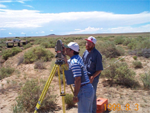
Bacterial contamination of shellfish in Dungeness Bay, northwestern Washington, resulted in closure of commercial shellfish harvesting in April 2000. The shellfish harvest is an important Tribal economic resource. In cooperation with the Jamestown S'Klallam Tribe's Water Resources Department, the USGS sampled water from the Dungeness River at three sites for analysis of suspended sediment. The collected data will help Tribal scientists with their contamination study. In May 2000, the Tribe and USGS invited news reporters to the Dungeness River for a demonstration of USGS sampling techniques to publicize the work being done on the bacteria problem. A Tribal natural resource planner for the Jamestown S'Klallam Tribe was present to answer reporters' questions, while a USGS hydrologist and a USGS hydrologic technician demonstrated sampling methods. Contact: John M. Clemens, 253-428-3600, ext. 2635, jclemens@usgs.gov
Surface-Water Quality Training for the Karuk Tribe of California.
USGS scientists are training Karuk Tribal personnel in water-quality sampling, measurement, and quality assurance/quality control procedures. The training builds Tribal capability to manage water resources. Contact: Jim Bowers, 760-247-1401,
Streamgaging by the Hoopa Valley Tribe.
Hoopa Valley Tribal employees are operating four gaging stations in the Trinity River watershed under general direction and quality assurance review by USGS scientists. Tribal employees have attended USGS classes on sediment measurement in addition to on-the-job training during USGS field work. As part of the Trinity River Restoration Program, the Hoopa Valley Tribe is planning to expand its role in stream discharge measurements and sediment sampling. Contact: Jim Bowers, 760-247-1401, jcbowers@usgs.gov
| GIS Assistance-Historical Ground-Water Information. The USGS provided a bibliography and copies of individual ground-water reports to the Agua Caliente Band of Cahuilla Indians. The Tribal Government is developing a Geographic Information System (GIS) to evaluate its ground-water resources in the Palm Springs, California area. This includes extracting historical data from the USGS and other sources. In cooperation with the Water Resources Center Archives at the University of California, Berkeley, all identified references were made available to the Agua Caliente Band. Contact: Walter Swain, 916-278-3024, wcswain@usgs.gov |
 |
Surface-Water Monitoring Stations.
The USGS operates the following surface-water monitoring stations, usually with cooperative funding from the Tribe, the Bureau of Indian Affairs (BIA), or a third party.
| Number of Stations | Cooperator | Contact |
|---|---|---|
| 2 | Seminole Tribe of Florida & South Florida Water Management District (includes 2 continuous recorders with Tribal nutrient autosamplers) | Mitch Murray-Florida, 305-717-5827, mmurray@usgs.gov |
| 1 1 1 1 1 |
Bad River Band of Lake Superior Chippewa Indians Menominee Indian Tribe of Wisconsin Oneida Tribe of Wisconsin Mohican Nation, Stockbridge-Munsee Band Lac du Flambeau Band of Lake Superior Chippewa Indians |
Barry Holmstrom-Wisconsin, 608-821-3831, bkholmst@usgs.gov |
| 2 | Three Affiliated Tribes | Wayne R. Berkas- North Dakota, 701-250-7429, wrberkas@usgs.gov |
| 4 3 1 1 |
Bureau of Indian Affairs Oglala Sioux Tribe Standing Rock Sioux Tribe Sisseton-Wahpeton Sioux Tribe |
Ralph Teller-South Dakota, 605-355-4560 ext. 222, rwteller@usgs.gov |
| 2 9 7 4 11 |
Fort Peck Assiniboine and Sioux Tribes Confederated Salish and Kootenai Tribes Blackfeet Nation Northern Cheyenne Tribe Bureau of Indian Affairs |
Ronald R. Shields-Montana, 406-457-5900, rshields@usgs.gov |
| 19 | BIA with the Joint Business Council of the Northern Arapaho and Eastern Shoshone Tribes (Wind River Reservation) | Bob Swanson-Wyoming, 307-778-2931, rswanson@usgs.gov |
| 2 | Southern Ute Indian Tribe | Bob Boulger-Colorado, 970-245-5257 ext. 21, rboulger@usgs.gov |
| 5 2 |
Bureau of Indian Affairs Pueblo of Zuni |
Michael Roark-New Mexico, 505-830-7954, mroark@usgs.gov |
| 1 4 |
Nez Perce Tribe Bureau of Indian Affairs |
Thomas S. Brennan-Idaho, 208-387-1366, tbrennan@usgs.gov |
| 1 3 1 2 2 3 6 1 2 |
Bureau of Indian Affairs & Peabody Coal Co. (Navajo Reservation) Bureau of Indian Affairs & Peabody Coal Co. (Hopi Reservation) Arizona Department of Water Resources (Navajo Reservation) Hopi Tribe Havasupai Tribe Hualapai Tribe Yavapai-Prescott Indian Tribe (2 continuous records and 4 crest-stage gages) Tohono O´odham Nation Pueblo of Zuni |
Christopher Smith-Arizona 520-670-6671 ext. 251, cfsmith@usgs.gov |
| 5 24 1 2 1 |
Pyramid Lake Paiute Tribe Walker River Paiute Tribe Paiute Tribe Shoshone-Paiute Tribes Summit Lake Paiute Tribe |
Kerry Garcia-Nevada, 775-887-7659, ktgarcia@usgs.gov |
| 4 2 1 1 1 1 1 1 7 7 7 |
Confederated Tribes and Bands of the Yakama Nation Nisqually Indian Tribe Quinault Indian Nation Makah Nation Quileute Tribe Coeur D´Alene Tribe Lower Elwha Tribal Community of the Lower Elwha Reservation Skokomish Tribe of Indians The Tulalip Tribes Bureau of Indian Affairs Confederated Tribes of the Umatilla Indian Reservation |
Robert Kimbrough-Washington, 253-428-3600 x 2608, rakimbro@usgs.gov |
| 11 1 |
Confederated Tribes of the Warm Springs Reservation Nez Perce Tribe |
Thomas A. Herrett-Oregon, 503-251-3239, herrett@usgs.gov |
| 7 3 1 |
Hoopa Valley Tribe Karuk Tribe of California Tule River Tribe |
Robert Mason-California, 916-278-3178, rrmason@usgs.gov |
| 1 1 1 |
Haida Corporation Alaska Native Tribal Health City of Klawock |
Bruce Bigelow-Alaska 907-586-7287, bbigelow@usgs.gov |
Surface-Water Monitoring Stations
The USGS operates the following surface-water monitoring stations, usually with cooperative funding from the Tribe, the Bureau of Indian Affairs (BIA), or a third party.
| Number of Stations | Cooperator | Contact |
|---|---|---|
| 2 | Seminole Tribe of Florida & South Florida Water Management District (includes 2 continuous recorders with Tribal nutrient autosamplers) | Mitch Murray-Florida, 305-717-5827, mmurray@usgs.gov |
| 1 1 1 1 1 |
Bad River Band of Lake Superior Chippewa Indians Menominee Indian Tribe of Wisconsin Oneida Tribe of Wisconsin Mohican Nation, Stockbridge-Munsee Band Lac du Flambeau Band of Lake Superior Chippewa Indians |
Barry Holmstrom-Wisconsin, 608-821-3831, bkholmst@usgs.gov |
| 2 | Three Affiliated Tribes | Wayne R. Berkas- North Dakota, 701-250-7429, wrberkas@usgs.gov |
| 4 3 1 1 |
Bureau of Indian Affairs Oglala Sioux Tribe Standing Rock Sioux Tribe Sisseton-Wahpeton Sioux Tribe |
Ralph Teller-South Dakota, 605-355-4560 ext. 222, rwteller@usgs.gov |
| 2 9 7 4 11 |
Fort Peck Assiniboine and Sioux Tribes Confederated Salish and Kootenai Tribes Blackfeet Nation Northern Cheyenne Tribe Bureau of Indian Affairs |
Ronald R. Shields-Montana, 406-457-5900, rshields@usgs.gov |
| 19 | BIA with the Joint Business Council of the Northern Arapaho and Eastern Shoshone Tribes (Wind River Reservation) | Bob Swanson-Wyoming, 307-778-2931, rswanson@usgs.gov |
| 2 | Southern Ute Indian Tribe | Bob Boulger-Colorado, 970-245-5257 ext. 21, rboulger@usgs.gov |
| 5 2 |
Bureau of Indian Affairs Pueblo of Zuni |
Michael Roark-New Mexico, 505-830-7954, mroark@usgs.gov |
| 1 4 |
Nez Perce Tribe Bureau of Indian Affairs |
Thomas S. Brennan-Idaho, 208-387-1366, tbrennan@usgs.gov |
| 1 3 1 2 2 3 6 1 2 |
Bureau of Indian Affairs & Peabody Coal Co. (Navajo Reservation) Bureau of Indian Affairs & Peabody Coal Co. (Hopi Reservation) Arizona Department of Water Resources (Navajo Reservation) Hopi Tribe Havasupai Tribe Hualapai Tribe Yavapai-Prescott Indian Tribe (2 continuous records and 4 crest-stage gages) Tohono O´odham Nation Pueblo of Zuni |
Christopher Smith-Arizona 520-670-6671 ext. 251, cfsmith@usgs.gov |
| 5 24 1 2 1 |
Pyramid Lake Paiute Tribe Walker River Paiute Tribe Paiute Tribe Shoshone-Paiute Tribes Summit Lake Paiute Tribe |
Kerry Garcia-Nevada, 775-887-7659, ktgarcia@usgs.gov |
| 4 2 1 1 1 1 1 1 7 7 7 |
Confederated Tribes and Bands of the Yakama Nation Nisqually Indian Tribe Quinault Indian Nation Makah Nation Quileute Tribe Coeur D´Alene Tribe Lower Elwha Tribal Community of the Lower Elwha Reservation Skokomish Tribe of Indians The Tulalip Tribes Bureau of Indian Affairs Confederated Tribes of the Umatilla Indian Reservation |
Robert Kimbrough-Washington, 253-428-3600 x 2608, rakimbro@usgs.gov |
| 11 1 |
Confederated Tribes of the Warm Springs Reservation Nez Perce Tribe |
Thomas A. Herrett-Oregon, 503-251-3239, herrett@usgs.gov |
| 7 3 1 |
Hoopa Valley Tribe Karuk Tribe of California Tule River Tribe |
Robert Mason-California, 916-278-3178, rrmason@usgs.gov |
| 1 1 1 |
Haida Corporation Alaska Native Tribal Health City of Klawock |
Bruce Bigelow-Alaska 907-586-7287, bbigelow@usgs.gov |
Water-Quality Monitoring Stations
The USGS collects water quality at the following sites:
| Number of Stations | Cooperator | Contact |
|---|---|---|
| 2 4 3 |
Three Affiliated Tribes Three Affiliated Tribes (lake sites) Spirit Lake Tribe (ground-water wells) Spirit Lake Tribe (wetlands) |
Wayne R. Berkas-North Dakota, 701-250-7429, wrberkas@usgs.gov |
| 4 | Yavapai-Prescott Indian Tribe | Christopher Smith-Arizona 520-670-6671x251, cfsmith@usgs.gov |
Ground-Water Monitoring Stations
The USGS operates the following ground-water monitoring stations:
| Number of Stations | Cooperator | Contact |
|---|---|---|
| 1 | USGS (on Fort Belknap Reservation-Assiniboine and Gros Ventre Tribes)* *The station was destroyed near the end of FY 2000 by vandals and won't be replaced |
Clarence L. Chambers-Montana, 406-457-5900, chambers@usgs.gov |
| 1 4 6 |
Collection of Basic Records (CBR) program (observation well located on Kaibab Band of Paiute Indians' Reservation) Yavapai-Prescott Indian Tribe Bureau of Indian Affairs (Navajo Nation and Hopi Tribe) |
Christopher Smith-Arizona 520-670-6671x251, cfsmith@usgs.gov |
| 15 3 6 |
Pechanga Band and Morongo Band of Mission Indians (wells for monthly depth to water) Pechanga Band and Morongo Band of Mission Indians (continuous record wells) Pechanga Band and Morongo Band of Mission Indians (wells for annual water quality) |
Robert Mason-California, 916-278-3178, rrmason@usgs.gov |
Sediment Monitoring Stations
The USGS operates the following sediment monitoring stations:
| Number of Stations | Cooperator | Contact |
|---|---|---|
| 3 1 |
Hopi Tribe Pueblo of Zuni |
Christopher Smith-Arizona 520-670-6671, ext. 251, cfsmith@usgs.gov |